Civil & Environmental Engineering
Traffic & Safety
Another area of strength at Oklahoma State is in the area of Traffic & Safety. Two research faculty members in this area. In the last three years these faculty members have been responsible for $1M in research funding, > 30 peer reviewed papers including two best paper awards, and > 50 conference presentations. In addition, Dr. Kelvin Wang was the president of the ASCE Transportation and Development Institute and was awarded the prestigious Francis C. Turner Award for innovation from the ASCE.
The focus of the transportation faculty at Oklahoma State University uses and develops state-of-the-art instruments that can be used to measure highway surface macro-texture, micro-texture, roughness, and skid resistance, and collect 1mm resolution 3D surface texture data at highway speed with full-lane coverage. This team is extending their work by including machine learning algorithms to identify distress and loss of surface friction without human intervention.
Transportation Capabilities at OSU
-
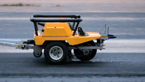
The Grip Tester

(ASTM E274) is a continuous friction measurement equipment (CFME) operating to determine the critical slip of an anti-braking system (ABS) at highway speed.
-
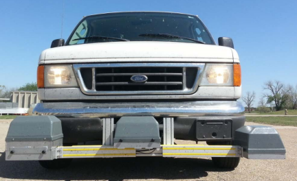
The AMES 8300 High Speed Profiler (ASTM E950)
is able to collect surface macro-texture data along with standard profile data at highway speeds. The point laser height sensor has a range of 8’’ (200mm) and a vertical resolution of 0.002’’ (0.05mm) and horizontal resolution of 0.05’’ (1.5mm). This instrument has been used by highway agencies, but the acquired texture profiles are used to obtain mean profile depth (MPD), a classic macro-texture indicator. The research team is actively developing higher resolution equipment that can scan a width of 20” at an increased resolution of roughly 10X. This again can be used to quantify the change in the surface texture along the wheel path. The data produced is shown in Figure 4c. This device can capture both macro- and micro-texture of a surface. This will provide a new tool to quantify surface friction and safety performance of highway pavements without direct measurement.
-
PaveVision3D laser imaging system
is a powerful tool that can collect 1mm 3D surface data with full-lane coverage. This tool can be used to quantify pavement distress, transverse and longitudinal profiles, and macro texture data at speeds up to 60 mph. The collected 1mm PaveVision3D data sets will be utilized to analyze the impacts of pavement conditions and surface characteristics on friction measurements and crash probabilities.
-
Comprised of an assembly of gyroscopes and accelerometers, the IMU
is a standard component to monitor the dynamically changing movements of autonomous vehicles. These vehicles provide a continuous stream of data related to the linear acceleration of the vehicle on three principal axes and three sets of rotation parameters (pitch, roll and heading). IMU not only provides vehicle dynamics information in terms of position, orientation, direction and velocity, but also whether changes in vehicle trajectory can be used to anticipate safety issues. The research team is using the IMU to obtain roadway geometric data acquisition including horizontal curve, longitudinal grade, and cross slope which are critical for roadway safety. In addition, the vertical acceleration data can be combined with the depth information from the 3D high speed surface texture profiler to calculate roadway smoothness and evaluate the ride ability and safety of all vehicles, especially under inclement weather conditions.
One concern with vehicle safety is the change in roadway surface texture with change in weather. Rain and icy conditions are known to reduce the surface texture of roadways and therefore reduce driver safety. To better understand how the roadway texture can change the RWI sensor (Figure 4f) can be used to collect real-time roadway surface data as well as air and roadway surface conditions, surface water depth, road condition (dry, wet, sleet, snow), ice percentage, wind speed etc. By combining this information with real time skid resistance data under various climate and operational conditions this can allow a new level of safety to be provided to the driving public in all weather conditions.